 4011 Laurel Drive West Richland WA 99353 Home For Sale | MLS #256551
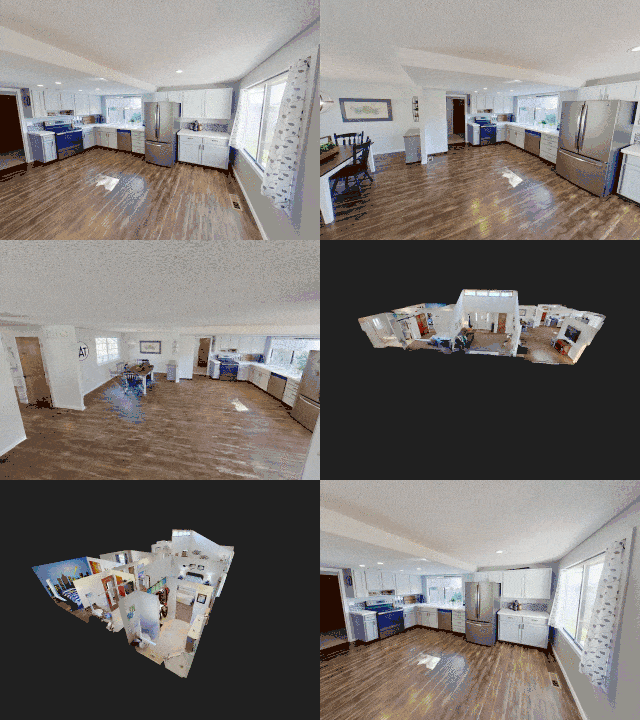
Take time to view this beautifully maintained 1,628 square foot, 3 bedrooms, 2 bath West Richland home. This home has an awesome large open kitchen floorplan, the family room has a connection for a pellet stove (currently sitting in the garage). Beautifully updated master bathroom! 2 car garage and extra RV/boat/trailer parking. Don't miss the office in the garage! This home is in a warm, welcoming, and established neighborhood. Close to shopping and major arterials. Located in the city voted the best place to raise a family. Beautiful yard, fully fenced, playset, 2 outbuildings, and entertaining space inside and out. Large open kitchen, living room, and family room. Recent updates - newer roof, hot water heater, flooring, carpet, and paint. For more information, please call or text Colleen @ 509.438.9344 THIS HOME IS NOW CLOSED.
Virtual Tours Best Viewed Full Screen:
Exclusively For Zillow:
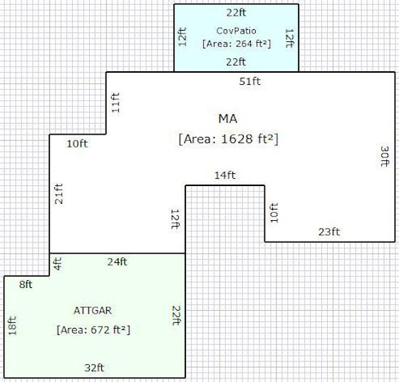
Floorplan & Other County Accessor Details:
About West Richland Washington
West Richland is a 22-square-mile (57 km2) city in Benton County, Washington, United States. The population was 11,811 at the 2010 census. The city is located within the Tri-Cities metropolitan area, which is centered around the cities of Richland, Kennewick, and Pasco (the Tri-Cities).
West Richland History
The original people of the region were the Chemnapum Indians (closely related to the Wanapum tribe), living near the mouth of the Yakima River. Lewis and Clark passed through the area in 1805, and an expedition of the Army Corps of Topographical Engineers headed by Robert E Johnson mapped the Yakima Valley in 1841.
In 1853, a road was authorized by Congress to pass through the Yakima valley, and passed through present-day West Richland - but settlement did not really begin until the late 1870s. The first schoolhouse was built in 1896 on the Van Horn Property just south of what is now Van Giesen Street. Benton County was created in 1905, Richland was incorporated in 1906, and the West Richland area was known as 'Lower Yakima'.
An irrigation canal from the north side of Horn Rapids Dam was built in 1908 to bring water into Richland.
The Yellowstone Trail, a national highway stretching from Albany, New York, to Seattle, was located through the Yakima Valley in 1917 and 1918. It crossed the Fallon Bridge between Richland and West Richland and then proceeded directly west to Kiona.
During the 1940s, the city of Richland was built, run and maintained by the War Department for the duration of the Manhattan Project. A number of residents had chafed at the government's regulations, and as a result many of them had moved across the Yakima River, where it was possible to purchase land and own (rather than rent) a house.
Carl Heminger purchased some 80 acres (320,000 m2) in 1948, and laid out plans for a city. It was proposed that it be named Heminger City (presumably after himself), but in 1949 the townspeople chose the name Enterprise instead. Heminger moved a mile down the road in protest, and platted a small community there called Heminger City. This was eventually incorporated in the West Richland City limits. When the time came in 1955 to incorporate the town, it was decided to rename to West Richland, taking advantage of the already well-known status of nearby Richland.
West Richland was officially incorporated on June 17, 1955, combining the two towns of Heminger City and Enterprise.
In 2008 West Richland was the location of the speed test for the fastest production car in the world (Aero SSC TT) at over 250 mph (400 km/h). [Source: Wikipedia]
Posted by Colleen Lane on

Leave A Comment